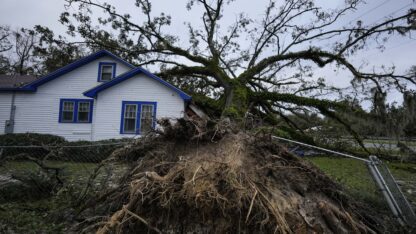
Helene entered Georgia as a Category 2 hurricane early Friday morning, bringing wind gusts as high as 100 mph and rising river heights throughout Atlanta.
The storm left over 1 million people without power and 11 people dead — including one first responder.
Atlantans got a taste of the bad weather before Helene even made landfall. Central and north Georgia were in moderate to severe drought conditions before Helene, but steady rains began Wednesday, Sept. 25, bringing several inches of rain and preliminary flooding.
“The soils are already saturated from the previous rainfall amounts that we’ve had the past 24 hours,” said state climatologist Bill Murphey on the eve of Helene’s landfall. These rains weren’t part of the hurricane, though — according to Murphey, the rain was from a cold front preceding the storm.
This meant that when the first rain bands of the actual hurricane arrived in Atlanta, the ground couldn’t hold any more water. The deluge of rain arriving with Helene ran off, causing flooding in streets, neighborhoods and rivers.
“It was a maximum, all-time, 48-hour total [rain] max for Atlanta,” Murphey said. Atlanta received a record 11-point-12 inches of rain in a 48-hour period, according to equipment at Hartsfield-Jackson International Airport.
That beat the previous record by over 1.5 inches, which was set back in 1886, making Helene a real outlier in Atlanta’s storm history – -somewhere between a 1-in-200-year and a 1-in-500-year storm, according to Murphey.
Murphey said that even though the rain and wind have passed, Atlantans can expect river heights to continue rising over the weekend.
“It’ll take a lot of that water time to work its way into the river systems from streams and tributaries and then eventually make its way down toward bigger watersheds,” the climatologist said.
While the Chattahoochee didn’t break its height records in most places, the National Weather Prediction Center’s gauges on the river show it entering major flooding levels in several parts of Atlanta, including Smyrna, Vinings and Buckhead.
In these places, the river reached over 25 feet and is predicted to continue rising to over 30 feet in height. This is far above the average river height for previous weeks, which in many areas was about 3-5 feet high.
Making a strong storm
Murphey said a lot of people compared Helene’s development to Hurricane Opal, which hit Atlanta in October 1995. He said Helene and Opal had some similarities, such as the cold front that arrived first, as well as their fast-moving nature.
Murphey describes Helene’s speed as a mixed bag. The high winds are dangerous, but the storm isn’t stagnant over particular towns, dumping dangerous amounts of water all at once. What stuck out to him about Helene was just how large and wide of a storm it is.
Murphey said several factors contributed to making Helene so strong, including normally high sea surface temperatures caused by climate change fed into the hurricane. Murphey also noted that there had been weak vertical wind shear over the Atlantic and weak Atlantic tropical trade winds — two types of winds that tear apart hurricanes before they build up strength.
Overall, Helene conformed to the overall hurricane trend in recent years that Atlantic hurricanes are wetter and dump more water as climate change worsens.